 BGS Hosted Metadata
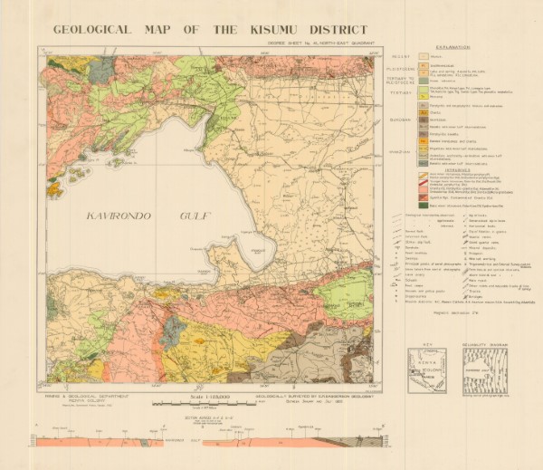
Geological Map of the Kisumu District
Degree Sheet: 41 NE, Sheet Number (Directorate of Overseas Survey): Not applicable, Report: Not applicable
Simple
- Date (Publication)
- 1952
- Edition
-
1
- Presentation form
- Digital map
- Collective title
-
Geological Map 1: 125 000 scale
- Status
- Completed
- Point of contact
-
Organisation name Individual name Electronic mail address Role Author Publisher Ministry of Petroleum and Mining (National Geodata Centre for Kenya)
Custodian Ministry of Petroleum and Mining (National Geodata Centre for Kenya)
Point of contact Owner
- Maintenance and update frequency
- Not planned
- Keywords
-
-
Geology
-
- Use limitation
-
Internal Only
- Access constraints
- Other restrictions
- Other constraints
-
Internal Only
- Other constraints
- No specifed conditions apply
- Denominator
- 125000
- Language
- English
- Topic category
-
- Geoscientific information
- Description
-
Kisumu District
))
- Supplemental Information
-
{"Translation Needs":"",
"Number of pages (Hardcopy)":"",
"Archive Location (Hardcopy)":"",
"Location in Archive (Hardcopy)":"",
"Risk and Impact":"",
"Vital asset to the organisation?":"",
"Current Asset Volume":"4.64",
"Digitalizing status":"Scanned & Georeferenced",
"Scanned Date":"",
"Name of Staff Scanning":"",
"Digital Asset location":" http://gdcs1.gdc.com/SpatialData/Raster/Geological/Scale_1_125000/Kisumu_District.JPG, http://gdcs1.gdc.com/SpatialData/Raster/Geological/Scale_1_125000/Tiff/Kisumu_200_dpi.tif",
"Retention period":"",
"Shared with":"",
"Comments":""}
- Reference system identifier
- 4210
- Distribution format
-
Name Version .jpg
.tiff
- OnLine resource
-
Protocol Linkage Name http://gdcs1.gdc.com/SpatialData/Raster/Geological/Scale_1_125000/Kisumu_District.JPG Geological Map of the Kisumu District
- OnLine resource
-
Protocol Linkage Name http://gdcs1.gdc.com/SpatialData/Raster/Geological/Scale_1_125000/Tiff/Kisumu_200_dpi.tif Geological Map of the Kisumu District
- Statement
-
Scanned copy of published map
Metadata
- File identifier
- 022382ee-3744-4c32-a072-7329337de7c8 XML
- Metadata language
- English
- Parent identifier
-
Geological Map 1: 125 000 scale
Geological Map 1: 125 000 scale
- Hierarchy level
- Dataset
- Date stamp
- 2019-10-22
- Metadata standard name
-
National Geodata Centre for Kenya Schema
- Metadata standard version
-
1.0
- Metadata author
-
Organisation name Individual name Electronic mail address Role Ministry of Petroleum and Mining (National Geodata Centre for Kenya)
enquiries
Point of contact
)))
