 BGS Hosted Metadata
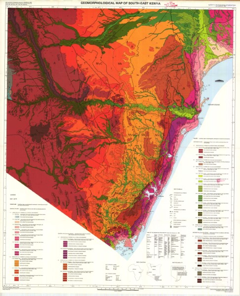
Geomorphological Map of South East Kenya
Map showing a range of geomorphology environments across south east Kenya. These include areas formed in a littoral, paralic, denudational, volcanic and fluvial environments. These are shown for coastal, interior hills and plateaus, interior plains and coastal hills and plateaus. Map is part of the Coast Province Geoscience Project financed by the Netherlands Foundation for the Advancement of Tropical Research (WOTRO).
Simple
- Date (Publication)
- 1988
- Edition
-
1
- Presentation form
- Digital map
- Status
- Completed
- Point of contact
-
Organisation name Individual name Electronic mail address Role A.P. Oosterom
Author Publisher Ministry of Petroleum and Mining (National Geodata Centre for Kenya)
Custodian Ministry of Petroleum and Mining (National Geodata Centre for Kenya)
Point of contact Owner
- Maintenance and update frequency
- Not planned
- Keywords
-
-
Geomorphology
-
- Use limitation
-
Internal Only
- Access constraints
- Other restrictions
- Other constraints
-
Internal Only
- Other constraints
- No specifed conditions apply
- Denominator
- 500000
- Language
- English
- Topic category
-
- Environment
- Description
-
Kenya
- Supplemental Information
-
{"Translation Needs":"",
"Number of pages (Hardcopy)":"",
"Archive Location (Hardcopy)":"",
"Location in Archive (Hardcopy)":"",
"Risk and Impact":"",
"Vital asset to the organisation?":"",
"Current Asset Volume":"3.06",
"Digitalizing status":"Scanned",
"Scanned Date":"",
"Name of Staff Scanning":"",
"Digital Asset location":" http://gdcs1.gdc.com/SpatialData/Raster/Geological/Geomorphology/Geomorphological_Map_of_South_East_Kenya.jpg",
"Retention period":"",
"Shared with":"",
"Comments":""}
- Distribution format
-
Name Version .jpg
- OnLine resource
-
Protocol Linkage Name http://gdcs1.gdc.com/SpatialData/Raster/Geological/Geomorphology/Geomorphological_Map_of_South_East_Kenya.jpg Geomorphological Map of South East Kenya
- Statement
-
This map is forms appendx 1 of the report 'The Geomorphology of Southeast Kenya' by A.P. Oosterom (1988). It is the only version known to have been published. Scanned copy of published map.
Metadata
- File identifier
- 268d3a68-7850-47cf-b9fa-08104b4fc9df XML
- Metadata language
- English
- Hierarchy level
- Dataset
- Date stamp
- 2019-10-22
- Metadata standard name
-
National Geodata Centre for Kenya Schema
- Metadata standard version
-
1.0
- Metadata author
-
Organisation name Individual name Electronic mail address Role Ministry of Petroleum and Mining (National Geodata Centre for Kenya)
enquiries
Point of contact
