 BGS Hosted Metadata
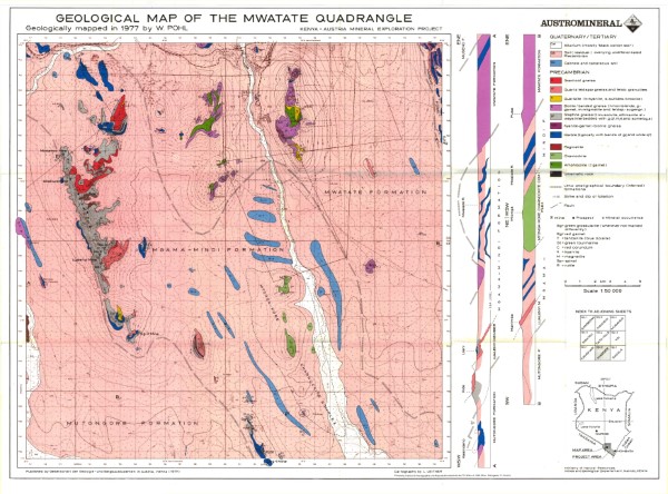
195/2 Geological Map of the Mwatate Quadrangle
195/2 Geological Map of the Mwatate Quadrangle
Simple
- Date (Publication)
- 1978
- Edition
-
1
- Presentation form
- Digital map
- Status
- Completed
- Point of contact
-
Organisation name Individual name Electronic mail address Role Author Ministry of Mines and Natural Resources (Mines and Geological Department)
Publisher Ministry of Petroleum and Mining (National Geodata Centre for Kenya)
Custodian Ministry of Petroleum and Mining (National Geodata Centre for Kenya)
Point of contact Owner
- Maintenance and update frequency
- Not planned
- Keywords
-
-
Geology
-
- Use limitation
-
Internal Only
- Access constraints
- Other restrictions
- Other constraints
-
Internal Only
- Other constraints
- No specifed conditions apply
- Denominator
- 50000
- Language
- English
- Topic category
-
- Geoscientific information
- Description
-
Map are 195/2
))
- Supplemental Information
-
{"Translation Needs":"",
"Number of pages (Hardcopy)":"",
"Archive Location (Hardcopy)":"",
"Location in Archive (Hardcopy)":"",
"Risk and Impact":"",
"Vital asset to the organisation?":"",
"Current Asset Volume":"6.99",
"Digitalizing status":"Scanned",
"Scanned Date":"",
"Name of Staff Scanning":"",
"Digital Asset location":" http://gdcs1.gdc.com/SpatialData/Raster/Geological/Scale_1_50000/195_2_Mwatate_Quadrangle_Area.jpg, http://gdcs1.gdc.com/SpatialData/Raster/Geological/Scale_1_50000/Tiff/Mwatate.tif",
"Retention period":"",
"Shared with":"",
"Comments":""}
- Distribution format
-
Name Version .jpg
.tiff
- OnLine resource
-
Protocol Linkage Name http://gdcs1.gdc.com/SpatialData/Raster/Geological/Scale_1_50000/195_2_Mwatate_Quadrangle_Area.jpg 195/2 Geological Map of the Mwatate Quadrangle
- OnLine resource
-
Protocol Linkage Name http://gdcs1.gdc.com/SpatialData/Raster/Geological/Scale_1_50000/Tiff/Mwatate.tif 195/2 Geological Map of the Mwatate Quadrangle
- Statement
-
Single version of the maps was published. No subsequent versions or updates have been identified.
Metadata
- File identifier
- 42e2238d-eb90-4621-bfc1-74897af6034a XML
- Metadata language
- English
- Hierarchy level
- Dataset
- Date stamp
- 2019-10-22
- Metadata standard name
-
National Geodata Centre for Kenya Schema
- Metadata standard version
-
1.0
- Metadata author
-
Organisation name Individual name Electronic mail address Role Ministry of Petroleum and Mining (National Geodata Centre for Kenya)
enquiries
Point of contact
)))
