 BGS Hosted Metadata
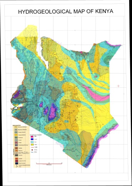
Hydrogeological Map of Kenya Arc1960 (Current)
Based on the 1: 1 million geological map this interpretation shows groundwater potential classed as High, Good, Low, Poor. No information is available as to the origin of this interpreation or the source data upon which it is based.
Simple
- Date (Publication)
- Edition
-
1
- Presentation form
- Digital map
- Status
- Completed
- Point of contact
-
Organisation name Individual name Electronic mail address Role Author Publisher Ministry of Petroleum and Mining (National Geodata Centre for Kenya)
Custodian Ministry of Petroleum and Mining (National Geodata Centre for Kenya)
Point of contact Owner
- Maintenance and update frequency
- Not planned
- Keywords
-
-
Hydrogeology
-
Geology
-
- Use limitation
-
Internal Only
- Access constraints
- Other restrictions
- Other constraints
-
Internal Only
- Other constraints
- No specifed conditions apply
- Denominator
- 1000000
- Language
- English
- Topic category
-
- Geoscientific information
- Description
-
Kenya
- Supplemental Information
-
{"Translation Needs":"",
"Number of pages (Hardcopy)":"",
"Archive Location (Hardcopy)":"",
"Location in Archive (Hardcopy)":"",
"Risk and Impact":"",
"Vital asset to the organisation?":"",
"Current Asset Volume":"3.01",
"Digitalizing status":"Scanned",
"Scanned Date":"",
"Name of Staff Scanning":"",
"Digital Asset location":" http://gdcs1.gdc.com/SpatialData/Raster/Geological/Hydrogeological/Current_Arc_1960_DD/Hydrogeological_Map.jpg",
"Retention period":"",
"Shared with":"",
"Comments":""}
- Distribution format
-
Name Version .jpg
- OnLine resource
-
Protocol Linkage Name http://gdcs1.gdc.com/SpatialData/Raster/Geological/Hydrogeological/Current_Arc_1960_DD/Hydrogeological_Map.jpg Hydrogeological Map of Kenya Arc1960 (Current)
- Statement
-
Stand alone map, which contains no reference to its origin either in terms of publishing or the data it contains.
Metadata
- File identifier
- 48814ad1-47ac-48b8-806c-17246e9ccc65 XML
- Metadata language
- English
- Hierarchy level
- Dataset
- Date stamp
- 2019-10-22
- Metadata standard name
-
National Geodata Centre for Kenya Schema
- Metadata standard version
-
1.0
- Metadata author
-
Organisation name Individual name Electronic mail address Role Ministry of Petroleum and Mining (National Geodata Centre for Kenya)
enquiries
Point of contact
