 BGS Hosted Metadata
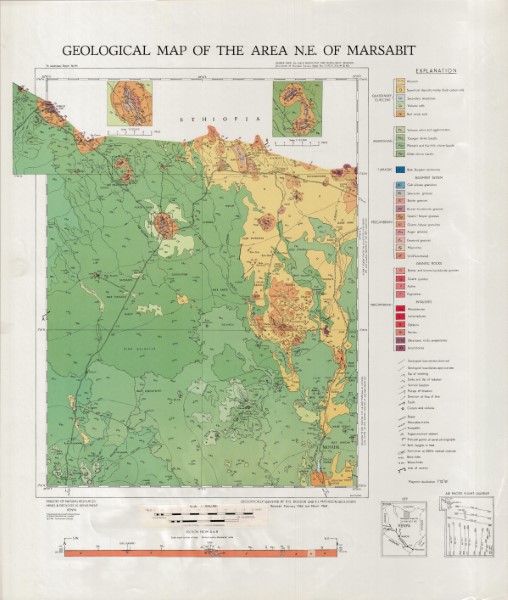
Geological map of the North East of Marsabit
Single 1: 300 000 scale geologcal map covering a section of northern Kenya along the border with Ethiopia.
Known by the reference Geological sheet 13. Associated with Report 94
Simple
- Date (Publication)
- 1969
- Edition
-
1
- Presentation form
- Digital map
- Status
- Completed
- Point of contact
-
Organisation name Individual name Electronic mail address Role Author Ministry of Mines and Natural Resources (Mines and Geological Department)
Publisher Ministry of Petroleum and Mining (National Geodata Centre for Kenya)
Custodian Ministry of Petroleum and Mining (National Geodata Centre for Kenya)
Point of contact Owner
- Maintenance and update frequency
- Not planned
- Keywords
-
-
Geology
-
- Use limitation
-
Internal Only
- Access constraints
- Other restrictions
- Other constraints
-
Internal Only
- Other constraints
- No specifed conditions apply
- Denominator
- 300000
- Language
- English
- Topic category
-
- Geoscientific information
- Description
-
Marsabit
))
- Supplemental Information
-
{"Translation Needs":"",
"Number of pages (Hardcopy)":"",
"Archive Location (Hardcopy)":"",
"Location in Archive (Hardcopy)":"",
"Risk and Impact":"",
"Vital asset to the organisation?":"",
"Current Asset Volume":"19.75",
"Digitalizing status":"Scanned",
"Scanned Date":"",
"Name of Staff Scanning":"",
"Digital Asset location":" http://gdcs1.gdc.com/SpatialData/Raster/Geological/Scale_1_300000/North_East_of_Marsabit.jpg, http://gdcs1.gdc.com/SpatialData/Raster/Geological/Scale_1_300000/tiff/North_East_of_Marsabit.tiff",
"Retention period":"",
"Shared with":"",
"Comments":""}
- Distribution format
-
Name Version .jpg
.tiff
- OnLine resource
-
Protocol Linkage Name http://gdcs1.gdc.com/SpatialData/Raster/Geological/Scale_1_300000/North_East_of_Marsabit.jpg Geological map of the North East of Marsabit
- OnLine resource
-
Protocol Linkage Name http://gdcs1.gdc.com/SpatialData/Raster/Geological/Scale_1_300000/tiff/North_East_of_Marsabit.tiff Geological map of the North East of Marsabit
- Statement
-
Version 1, no additional versions or updates have been published. Scanned copy of published paper map
Metadata
- File identifier
- 5869a326-e042-4a24-9527-50fcb957883d XML
- Metadata language
- English
- Hierarchy level
- Dataset
- Date stamp
- 2019-10-22
- Metadata standard name
-
National Geodata Centre for Kenya Schema
- Metadata standard version
-
1.0
- Metadata author
-
Organisation name Individual name Electronic mail address Role Ministry of Petroleum and Mining (National Geodata Centre for Kenya)
enquiries
Point of contact
)))
