 BGS Hosted Metadata
GBR BGS Offshore 1:250 000 scale marine bedrock linear features
The BGS Offshore Bedrock 250k dataset is vector data which reflects the offshore bedrock geological of the UK and some of its adjacent waters at 1:250,000 scale. This comprehensive product provides a digital compilation of the paper maps published by BGS at the same scale, as well as, additional re-interpretations from regional geological studies. The composition, age and deformational history of the rocks underlying the seabed (bedrock) are important for a range of stakeholders, including marine spatial planners and offshore developers. The dataset is arranged in two GIS layers: Bedrock Lithostratigraphy and Bedrock Structural Geology. The polygons within the Bedrock Lithostratigraphy layer show the spatial distribution of the principal lithostratigraphical units (formations and groups). The lines within the Structural Geology layer show the location and extent of known structural features such as faults and folds. This broadscale dataset was derived from geophysical data (e.g. airgun, boomer, sparker, sidescan sonar, magnetometer, gravity meter) and data obtained from commercial wells and BGS shallow boreholes. The variations in data density will be reflected in the detail of the mapping.
Simple
- Date (Revision)
- 2022-04-08T08:28:01
- Status
- Completed
- Point of contact
-
Organisation name Individual name Electronic mail address Role British Geological Survey
Garry Baker
Point of contact
- Theme
-
-
Geology
-
Marine
-
Offshore
-
Bedrock
-
OneGeology
-
continent@Europe
-
subcontinent@Northern Europe
-
geographicarea@United Kingdom of Great Britain and Northern Ireland
-
dataprovider@British Geological Survey
-
serviceprovider@British Geological Survey
-
DS_TOPIC@geoscientificinformation
-
DS_DATE@2022
-
thematic@Marine Geology
-
thematic@Exploration
-
thematic@Bedrock
-
- Topic category
-
- Geoscientific information
))
- Reference system identifier
- CRS:84
- Reference system identifier
- EPSG:4326
- Reference system identifier
- EPSG:4258
- Reference system identifier
- EPSG:32631
- Reference system identifier
- EPSG:3857
- Distribution format
-
Name Version
- OnLine resource
-
Protocol Linkage Name OGC:WMS-1.3.0-http-get-map
https://map.bgs.ac.uk/arcgis/services/Offshore/Products_WMS/MapServer/WmsServer BGS250k.LinearBedrock
text/html
https://metadata.bgs.ac.uk/geonetwork/srv/eng/csw?SERVICE=CSW&REQUEST=GetRecordById&ID=e605cf9b-7fb3-0431-e044-0003ba9b0d98&elementSetName=full&OutputSchema=http://www.isotc211.org/2005/gmd&version=2.0.2& BGS250k.LinearBedrock (MetadataURL)
image/gif
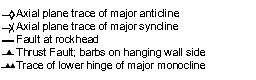
https://map.bgs.ac.uk/BGS_WMS/legends/offshore/marine_bedrock_linear.gif GBR BGS 250k marine bedrock linear features (LegendURL)
- Hierarchy level
- Dataset
Metadata
- File identifier
- 5e434eafee6a95c31afd094ee70ba88cba683f82 XML
- Metadata language
-
eng
- Character set
- UTF8
- Hierarchy level
- Dataset
- Date stamp
- 2022-04-08T08:28:01
- Metadata standard name
-
ISO 19115:2003/19139
- Metadata standard version
-
1.0
- Metadata author
-
Organisation name Individual name Electronic mail address Role British Geological Survey
Garry Baker
Point of contact


)))
