 BGS Hosted Metadata
GBR BGS Offshore 1:250 000 scale sea bed sediment
The BGS Seabed Sediments 250k dataset is vector data is vector data which reflects the distribution of seabed substrate types of the UK and some of its adjacent waters at 1:250,000 scale. This comprehensive product provides a digital compilation of the paper maps published by BGS at the same scale, as well as, additional re-interpretations from regional geological studies. The seabed is commonly covered by sediments that form a veneer or thicker superficial layer of unconsolidated material above the bedrock. These sediments are classified based on their grain size reflecting the environment in which were deposited. This information is important to a range of stakeholders, including marine habitat mappers, marine spatial planners, offshore industries (in particular, the dredging and aggregate industries). This dataset was primarily based on seabed grab samples of the top 0.1 m, combined with cores, dredge samples and sidescan sonar acquired during mapping surveys since the early 1970s. The variations in data density will be reflected in the detail of the mapping.
Simple
- Date (Revision)
- 2022-04-08T08:28:01
- Status
- Completed
- Point of contact
-
Organisation name Individual name Electronic mail address Role British Geological Survey
Garry Baker
Point of contact
- Theme
-
-
Geology
-
Marine
-
Offshore
-
Sea-bed
-
Sediment
-
OneGeology
-
continent@Europe
-
subcontinent@Northern Europe
-
geographicarea@United Kingdom of Great Britain and Northern Ireland
-
dataprovider@British Geological Survey
-
serviceprovider@British Geological Survey
-
DS_TOPIC@geoscientificinformation
-
DS_DATE@2022
-
thematic@Marine Geology
-
thematic@Exploration
-
thematic@Sedimentology
-
- Topic category
-
- Geoscientific information
))
- Reference system identifier
- CRS:84
- Reference system identifier
- EPSG:4326
- Reference system identifier
- EPSG:4258
- Reference system identifier
- EPSG:32631
- Reference system identifier
- EPSG:3857
- Distribution format
-
Name Version
- OnLine resource
-
Protocol Linkage Name OGC:WMS-1.3.0-http-get-map
https://map.bgs.ac.uk/arcgis/services/Offshore/Products_WMS/MapServer/WmsServer BGS250k.SBS
text/html
https://metadata.bgs.ac.uk/geonetwork/srv/eng/csw?SERVICE=CSW&REQUEST=GetRecordById&ID=9e32312c-b027-521b-e044-0003ba9b0d98&elementSetName=full&OutputSchema=http://www.isotc211.org/2005/gmd&version=2.0.2& BGS250k.SBS (MetadataURL)
image/gif
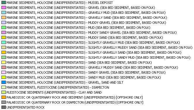
https://map.bgs.ac.uk/BGS_WMS/legends/offshore/sbs.gif GBR BGS 250k SBS (LegendURL)
- Hierarchy level
- Dataset
Metadata
- File identifier
- 82121a349392d5c2d1c4442a3605e72f20c415ae XML
- Metadata language
-
eng
- Character set
- UTF8
- Hierarchy level
- Dataset
- Date stamp
- 2022-04-08T08:28:01
- Metadata standard name
-
ISO 19115:2003/19139
- Metadata standard version
-
1.0
- Metadata author
-
Organisation name Individual name Electronic mail address Role British Geological Survey
Garry Baker
Point of contact


)))
