 BGS Hosted Metadata
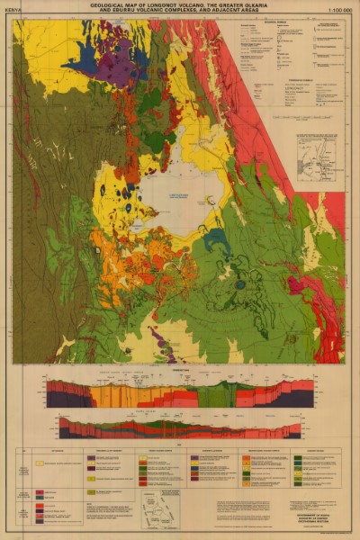
Geological Map of Longonot Volcano the Greater Olkaria and Eburru Volcanic Complexes and adjacent areas
The map focuses on the area around Lake Naivasha. It identifies the Rift valley marigins, Tandamara and Mount Maargaret, Eburru Volcanic Complex, Elmenteita and Ndabibi complex, Greater Olkaria Volcanic Complex and Longonot Volcano, classifying each by the formations found within them.
The map also indicates the location of other volcanic features including pyroclastic cones, eruption fissures, eruption centres. The map face also shows a series of detailed cross sections.
Simple
- Date (Publication)
- 1988
- Edition
-
1
- Presentation form
- Digital map
- Status
- Completed
- Point of contact
-
Organisation name Individual name Electronic mail address Role Author Ministry of Energy Geothermal Section
Publisher Ministry of Petroleum and Mining (National Geodata Centre for Kenya)
Custodian Ministry of Petroleum and Mining (National Geodata Centre for Kenya)
Point of contact Owner
- Maintenance and update frequency
- Not planned
- Keywords
-
-
Geology
-
- Use limitation
-
Internal Only
- Access constraints
- Other restrictions
- Other constraints
-
Internal Only
- Other constraints
- No specifed conditions apply
- Denominator
- 100000
- Language
- English
- Topic category
-
- Geoscientific information
- Begin date
- 1985
- End date
- 1987
- Description
-
Longonot Volcano and Greater Olkaria and Eburru areas.
))
- Supplemental Information
-
{"Translation Needs":"",
"Number of pages (Hardcopy)":"",
"Archive Location (Hardcopy)":"",
"Location in Archive (Hardcopy)":"",
"Risk and Impact":"",
"Vital asset to the organisation?":"",
"Current Asset Volume":"5.74",
"Digitalizing status":"Scanned",
"Scanned Date":"",
"Name of Staff Scanning":"",
"Digital Asset location":" http://gdcs1.gdc.com/SpatialData/Raster/Geological/Scale_1_100000/Longonot_Volcano_The_Greater_Olkaria_and_Eburru_Volcanic_Complexes_and_adjacent_areas.jpg",
"Retention period":"",
"Shared with":"",
"Comments":""}
- Distribution format
-
Name Version .jpg
- OnLine resource
-
Protocol Linkage Name http://gdcs1.gdc.com/SpatialData/Raster/Geological/Scale_1_100000/Longonot_Volcano_The_Greater_Olkaria_and_Eburru_Volcanic_Complexes_and_adjacent_areas.jpg Geological Map of Longonot Volcano the Greater Olkaria and Eburru Volcanic Complexes and adjacent areas
- Statement
-
The map was produced as a result of a Technical Co-operation agreement between the Government of the Republic of Keny and the United Kingdom of Great Britian and Northern Ireland (Overseas Development Administration). The work formed part of the Kenyan Governments 'Exploration for Geothermal Energy project and was carried out between 1985 and 1987 by the Geeothermal Section of the Kenyan Ministry of Energy and Regional Development and the British Geological Survey (Natural Environmental Research Council). e complilation includes data derived from the Kenyan \Power Company: postgraduate research programmes, notably Dr S.C. Scot of Plymouth Polytechnic and Dr C.M. Bliss of Lancaster University, both in the UK, UNDP and Japan International Co-operation Agency.
Since the original work was carried out and published no further updates or changes have been made.
Metadata
- File identifier
- 822c7574-edb4-4162-a482-6e0806abb17c XML
- Metadata language
- English
- Hierarchy level
- Dataset
- Date stamp
- 2019-10-22
- Metadata standard name
-
National Geodata Centre for Kenya Schema
- Metadata standard version
-
1.0
- Metadata author
-
Organisation name Individual name Electronic mail address Role Ministry of Petroleum and Mining (National Geodata Centre for Kenya)
enquiries
Point of contact
)))
