 BGS Hosted Metadata
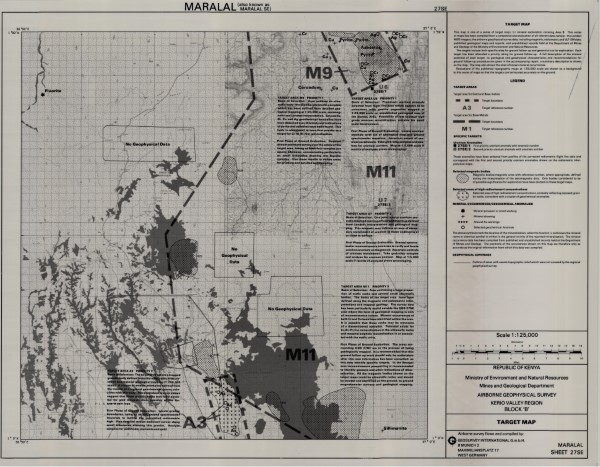
Tartget Map 27 SE
Tartget Map 27 SE
Simple
- Date (Publication)
- 1982
- Edition
-
1
- Presentation form
- Digital map
- Collective title
-
Airborne Geophysical Survey
- Status
- Completed
- Point of contact
-
Organisation name Individual name Electronic mail address Role Author Ministry of Mines and Natural Resources (Mines and Geological Department)
Publisher Ministry of Petroleum and Mining (National Geodata Centre for Kenya)
Custodian Ministry of Petroleum and Mining (National Geodata Centre for Kenya)
Point of contact Owner
- Maintenance and update frequency
- Not planned
- Keywords
-
-
Geophysics
-
- Use limitation
-
Internal Only
- Access constraints
- Other restrictions
- Other constraints
-
Internal Only
- Other constraints
- No specifed conditions apply
- Denominator
- 125000
- Language
- English
- Topic category
-
- Geoscientific information
- Begin date
- 1981
- End date
- 1982
- Description
-
Kerio Valley Region
- Supplemental Information
-
{"Translation Needs":"",
"Number of pages (Hardcopy)":"",
"Archive Location (Hardcopy)":"",
"Location in Archive (Hardcopy)":"",
"Risk and Impact":"",
"Vital asset to the organisation?":"",
"Current Asset Volume":"7.85",
"Digitalizing status":"Scanned",
"Scanned Date":"",
"Name of Staff Scanning":"",
"Digital Asset location":" http://gdcs1.gdc.com/SpatialData/Raster/Geological/Airborne_Geophysical_Survey/Kerio_Valley_Region/Block_B/Tartget_Map_27_SE.jpg",
"Retention period":"",
"Shared with":"",
"Comments":""}
- Distribution format
-
Name Version .jpg
- OnLine resource
-
Protocol Linkage Name http://gdcs1.gdc.com/SpatialData/Raster/Geological/Airborne_Geophysical_Survey/Kerio_Valley_Region/Block_B/Tartget_Map_27_SE.jpg Tartget Map 27 SE
- Statement
-
This data was captured as a stand alone project. The survey was flown by the West German companyGeosurvey International G.m.b.H. This surver data has not been revisted or updated and is stored as scanned versions of the original paper maps.
Metadata
- File identifier
- 96e84b01-5b0c-45a5-8600-369f10a26ea5 XML
- Metadata language
- English
- Parent identifier
-
Airborne Geophysical Survey
Airborne Geophysical Survey
- Hierarchy level
- Dataset
- Date stamp
- 2019-10-17
- Metadata standard name
-
National Geodata Centre for Kenya Schema
- Metadata standard version
-
1.0
- Metadata author
-
Organisation name Individual name Electronic mail address Role Ministry of Petroleum and Mining (National Geodata Centre for Kenya)
enquiries
Point of contact
