 BGS Hosted Metadata
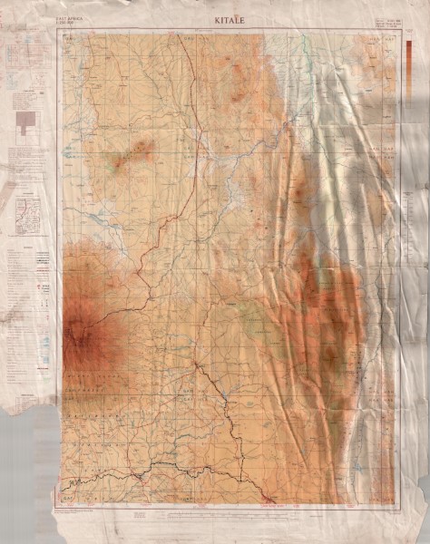
Kitale Topographic Map
Topographic map at 1: 250 000 scale which has been compiled from a series of exisiting maps. These include GSGS 4786 and GSGS 4787 (1: 50 000 scale), Mbale District, Survey of Kenya
(1: 250 000 scale) Block 63 Kalossia and Block 76 Taiti (1: 125 000 scale) GSGS 3999
(1: 250 000 scale).
Simple
- Date (Publication)
- 1959
- Edition
-
1
- Presentation form
- Digital map
- Collective title
-
GSGS4801
- Status
- Completed
- Point of contact
-
Organisation name Individual name Electronic mail address Role Author British War Office and Air Ministry
Publisher Ministry of Petroleum and Mining (National Geodata Centre for Kenya)
Custodian Ministry of Petroleum and Mining (National Geodata Centre for Kenya)
Point of contact Owner
- Maintenance and update frequency
- Not planned
- Keywords
-
-
Topography
-
- Use limitation
-
Internal Only
- Access constraints
- Other restrictions
- Other constraints
-
Internal Only
- Other constraints
- No specifed conditions apply
- Denominator
- 250000
- Language
- English
- Topic category
-
- Imagery base maps earth cover
- Description
-
Geographic area not described
))
- Supplemental Information
-
{"Translation Needs":"",
"Number of pages (Hardcopy)":"",
"Archive Location (Hardcopy)":"",
"Location in Archive (Hardcopy)":"",
"Risk and Impact":"",
"Vital asset to the organisation?":"",
"Current Asset Volume":"9.73",
"Digitalizing status":"Scanned & Georeferenced",
"Scanned Date":"",
"Name of Staff Scanning":"",
"Digital Asset location":" http://gdcs1.gdc.com/SpatialData/Raster/Topographic/Scale_1_250000_Series_GSGS_4801/Kitale.jpg",
"Retention period":"",
"Shared with":"",
"Comments":""}
- Reference system identifier
- Transverse Mercator, Clarke 1880
- Distribution format
-
Name Version .jpg
- OnLine resource
-
Protocol Linkage Name http://gdcs1.gdc.com/SpatialData/Raster/Topographic/Scale_1_250000_Series_GSGS_4801/Kitale.jpg Kitale Topographic Map
- Statement
-
Identified as version 1, no published amendments or updates have been identified
Metadata
- File identifier
- a3a7b46c-1fdd-49b7-9c83-646a9123fc87 XML
- Metadata language
- English
- Parent identifier
-
GSGS4801
GSGS4801
- Hierarchy level
- Dataset
- Date stamp
- 2019-10-22
- Metadata standard name
-
National Geodata Centre for Kenya Schema
- Metadata standard version
-
1.0
- Metadata author
-
Organisation name Individual name Electronic mail address Role Ministry of Petroleum and Mining (National Geodata Centre for Kenya)
enquiries
Point of contact
)))
