 BGS Hosted Metadata
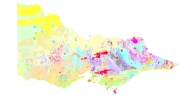
AU-VIC DPI 1:250k Basement Lithostratigraphy
This dataset contains primary geological data, namely outcropping/sub-cropping geological rock units and boundary types separating rock units. The polygon edges are constructed from the corresponding geological contacts and faults layer. Theme based on Victorian lithostratigraphy.
Simple
- Date (Revision)
- 2020-04-03T11:00:16
- Status
- Completed
- Point of contact
-
Organisation name Individual name Electronic mail address Role Geological Survey of Victoria, Australia
Paul A. MacDonald
Point of contact
- Theme
-
-
OneGeology
-
Seamless
-
Geology
-
Victoria
-
Australia
-
GeologicUnit
-
Lithostratigraphy
-
continent@Oceania
-
geographicarea@Australia
-
subarea@Victoria
-
dataprovider@Department of Primary Industries
-
serviceprovider@Department of Primary Industries
-
DS_TOPIC@geoscientificinformation
-
DS_DATE@2011-09-30
-
- Topic category
-
- Geoscientific information
))
- Reference system identifier
- EPSG:4326
- Reference system identifier
- CRS:84
- Distribution format
-
Name Version
- OnLine resource
-
Protocol Linkage Name OGC:WMS-1.3.0-http-get-map
http://gsv.vic.gov.au:80/onegeology/ows?SERVICE=WMS& oneg:AU-VIC_DPI_250k_BLS
text/html
http://geology.data.vic.gov.au/metadata/wms-layer/oneg/au-vic_dpi_250k_bls oneg:AU-VIC_DPI_250k_BLS (MetadataURL)
image/png
http://gsv.vic.gov.au:80/onegeology/ows?service=WMS&request=GetLegendGraphic&format=image%2Fpng&width=20&height=20&layer=oneg%3AAU-VIC_DPI_250k_BLS geology-stratigraphy (LegendURL)
image/png
http://gsv.vic.gov.au:80/onegeology/ows?service=WMS&request=GetLegendGraphic&format=image%2Fpng&width=20&height=20&layer=oneg%3AAU-VIC_DPI_250k_BLS&style=polygon Default Polygon (LegendURL)
- Hierarchy level
- Dataset
Metadata
- File identifier
- a55e4ddf32571ca0c07dd11a638f58ba4f5a59be XML
- Metadata language
-
eng
- Character set
- UTF8
- Hierarchy level
- Dataset
- Date stamp
- 2020-04-03T11:00:16
- Metadata standard name
-
ISO 19115:2003/19139
- Metadata standard version
-
1.0
- Metadata author
-
Organisation name Individual name Electronic mail address Role Geological Survey of Victoria, Australia
Paul A. MacDonald
Point of contact

)))
