 BGS Hosted Metadata
GBR BGS Hydrogeology
1:625 000 scale digital hydrogeological data aquifer classification
Simple
- Date (Revision)
- 2022-04-08T08:25:28
- Status
- Completed
- Point of contact
-
Organisation name Individual name Electronic mail address Role British Geological Survey
Garry Baker
Point of contact
- Theme
-
-
Hydrogeology
-
GeoIndex
-
aquifer
-
OneGeology
-
continent@Europe
-
subcontinent@Northern Europe
-
geographicarea@United Kingdom of Great Britain and Northern Ireland
-
dataprovider@British Geological Survey
-
serviceprovider@British Geological Survey
-
DS_TOPIC@geoscientificinformation
-
DS_DATE@2022
-
thematic@Aquifer
-
thematic@Hydrogeology
-
- Topic category
-
- Geoscientific information
N
S
E
W
))
- Reference system identifier
- CRS:84
- Reference system identifier
- EPSG:4326
- Reference system identifier
- EPSG:4258
- Reference system identifier
- EPSG:27700
- Reference system identifier
- EPSG:3857
- Distribution format
-
Name Version
- OnLine resource
-
Protocol Linkage Name OGC:WMS-1.3.0-http-get-map
https://map.bgs.ac.uk/arcgis/services/GeoIndex_Onshore/hydrogeology/MapServer/WmsServer? Hydrogeology
application/xml
https://metadata.bgs.ac.uk/geonetwork/srv/eng/csw?SERVICE=CSW&REQUEST=GetRecordById&ID=9df8df53-2aa9-37a8-e044-0003ba9b0d98&elementSetName=full&OutputSchema=http://www.isotc211.org/2005/gmd&version=2.0.2& Hydrogeology (MetadataURL)
image/png
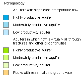
https://map.bgs.ac.uk/BGS_WMS/legends/geoindex/625khydro.png Hydrogeology aquifer classification 625k (LegendURL)
- Hierarchy level
- Dataset
Metadata
- File identifier
- b8c32d54331c5e2d5837dcb280195734c5fcd9df XML
- Metadata language
-
eng
- Character set
- UTF8
- Hierarchy level
- Dataset
- Date stamp
- 2022-04-08T08:25:28
- Metadata standard name
-
ISO 19115:2003/19139
- Metadata standard version
-
1.0
- Metadata author
-
Organisation name Individual name Electronic mail address Role British Geological Survey
Garry Baker
Point of contact


)))
