BGS Hosted Metadata
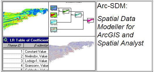
Arc SDM - Spatial Data Modeller for ArcGIS and Spatial Analyst
Spatial Data Modeller, SDM, is a collection of tools for use with GIS software for adding categorical maps with interval, ordinal, or ratio scale maps to produce a predictive map of where something of interest is likely to occur. The tools include the data-driven methods of Weights of Evidence, Logistic Regression, and two supervised and one unsupervised neural network methods, and categorical tools for a knowledge-driven method Fuzzy Logic. All of the tools have help files that include references to publications discussing the applications of the methods implemented in the tool. Several of the tools create output rasters, tables, or files that require the user to enter a name. Default values are provided in most cases to serve as suggestions of the style of naming that has been found useful. These names, following ArcGIS conventions, can be changed to meet the user’s needs. To make all of the features of SDM work properly it is required that several Environment parameters are set. See the discussion of Environment Settings below for the details. The Weights of Evidence, WofE, and Logistic Regression, LR, tools addresses area as the count of unit cells. It is assumed in the WofE and LR tools that the data has spatial units of meters. If your data has other spatial units, these WofE and LR tools may not work properly.
Website:
Simple
- Date (Creation)
- 2008-03-01
- Date (Publication)
- 2008-03-01
- Date (Revision)
- 2010-07-01
- Edition
-
10
- Citation identifier
-
https://www.mica-project.eu/
/
MICA_B3-5
MICA WP3 2018-11-03T15:16:00 Record extracted from Batch 3 spreadsheet
- Other citation details
-
No other citation details provided
- Purpose
-
Purpose for data generation is not known
- Status
- Completed
- Point of contact
-
Organisation name Individual name Electronic mail address Role University of Campinas
Resource provider
- Maintenance and update frequency
- As needed
- dataCentre
-
-
MICA
-
-
MICA ontology (TemporalScheme)
-
-
Recent (includes data from 2006 onwards)
-
-
MICA ontology (DataScheme)
-
-
General descriptive information / Website / Other (Website)
-
- Keywords
-
-
Requirement for data generation: Voluntary
-
- Keywords
-
-
Method of data or information generation: Academic research
-
-
GEMET Concepts
-
-
Exploration
-
-
MICA ontology (DomainScheme)
-
-
Mineral exploration
-
-
MICA ontology (DomainScheme)
-
-
Regional reconnaissance
-
-
MICA ontology (DomainScheme)
-
-
2D predictive mapping
-
-
MICA ontology (DomainScheme)
-
-
Mineral resources potential assessment/estimating undiscovered resources
-
-
MICA ontology (ValueSupplyChainScheme)
-
-
Exploration
-
-
MICA ontology (ValueSupplyChainScheme)
-
-
Regional reconnaissance
-
- Access constraints
- Other restrictions
- Use constraints
- Other restrictions
- Language
- English
- Topic category
-
- Geoscientific information
- Economy
- Description
-
Not applicable
- Geographic identifier
- Other group of countries (please provide more details)
- Hierarchy level
- Non geographic dataset
- Other
-
Individual item (e.g. a one-off academic paper or single website)
Conformance result
- Title
-
Data uncertainty
- Date
- Explanation
-
Are any uncertainty measures provided (e.g. standard errors, confidence intervals, etc.)?
- Pass
- No
Conformance result
- Title
-
Quality assurance procedures
- Date
- Explanation
-
Are quality assurance procedures described?
- Pass
- No
Conformance result
- Title
-
Information generation methods
- Date
- Explanation
-
Are data or information generation methods formally described?
- Pass
- Yes
Conformance result
- Title
-
Record review
- Date
- Other citation details
-
Reviewed by: British Geological Survey
- Explanation
-
Record validation
- Pass
- No
Conformance result
- Statement
-
Organisation source implies that information should be of good quality
Metadata
- File identifier
- d3d76fa7-d1da-472b-920a-3ff2bca90290 XML
- Metadata language
- English
- Character set
- MD_CharacterSetCode_utf8
- Hierarchy level
- Non geographic dataset
- Date stamp
- 2024-11-07
- Metadata standard name
-
ISO19115
- Metadata standard version
-
2003/Cor.1:2006
- Metadata author
-
Organisation name Individual name Electronic mail address Role British Geological Survey
Point of contact