 BGS Hosted Metadata
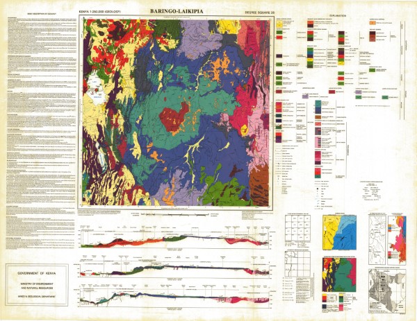
Baringo Laikipia Geology
Geological mapping (1984) was carried out as part of the Samburu Marsabit Geological Mapping and Mineral Exploration Prokect, a joint Kenyan - British Overseas Development Administration Technical Co-operation Project, staffed by the Kenyan Mines and Geological Department and the Brtish Geological Survey (formerly the Institute of Geological Science) of Natural Environment Research Council.
Series of 1: 250 000 scale geological maps captured in two phases. The maps cover central (phase 1) and northern Kenya (phase 2). The maps align with the 1: 500 000 scale map for the Northern Turkana area.
Simple
- Date (Publication)
- 1987
- Edition
-
1
- Presentation form
- Digital map
- Collective title
-
Kenya 1:250 000 (Geology)
- Status
- Completed
- Point of contact
-
Organisation name Individual name Electronic mail address Role Author Ministry of Mines and Natural Resources (Mines and Geological Department)
Publisher Ministry of Petroleum and Mining (National Geodata Centre for Kenya)
Custodian Ministry of Petroleum and Mining (National Geodata Centre for Kenya)
Point of contact Owner
- Maintenance and update frequency
- Not planned
- Keywords
-
-
Geology
-
- Use limitation
-
Internal Only
- Access constraints
- Other restrictions
- Other constraints
-
Internal Only
- Other constraints
- No specifed conditions apply
- Denominator
- 250000
- Language
- English
- Topic category
-
- Geoscientific information
- Description
-
Baringo Laikipia
))
- Supplemental Information
-
{"Translation Needs":"",
"Number of pages (Hardcopy)":"",
"Archive Location (Hardcopy)":"",
"Location in Archive (Hardcopy)":"",
"Risk and Impact":"",
"Vital asset to the organisation?":"",
"Current Asset Volume":"12.32",
"Digitalizing status":"Scanned & Georeferenced",
"Scanned Date":"",
"Name of Staff Scanning":"",
"Digital Asset location":" http://gdcs1.gdc.com/SpatialData/Raster/Geological/Scale_1_250000/Original_Arc1960_DD/Baringo_Laikipia.jpg, http://gdcs1.gdc.com/SpatialData/Raster/Geological/Scale_1_250000/Tiff/Baringo_Laikipia_200_dpi.tif",
"Retention period":"",
"Shared with":"",
"Comments":""}
- Distribution format
-
Name Version .jpg
.tiff
- OnLine resource
-
Protocol Linkage Name http://gdcs1.gdc.com/SpatialData/Raster/Geological/Scale_1_250000/Original_Arc1960_DD/Baringo_Laikipia.jpg Baringo Laikipia Geology
- OnLine resource
-
Protocol Linkage Name http://gdcs1.gdc.com/SpatialData/Raster/Geological/Scale_1_250000/Tiff/Baringo_Laikipia_200_dpi.tif Baringo Laikipia Geology
- Statement
-
The maps in this series are version 1, there is no evidence that the maps have been editied or updated and republished. Scanned copy of published paper map
Metadata
- File identifier
- e0b933de-36bb-46b7-931c-26020e50f038 XML
- Metadata language
- English
- Parent identifier
-
Kenya 1:250 000 (Geology)
Kenya 1:250 000 (Geology)
- Hierarchy level
- Dataset
- Date stamp
- 2019-10-22
- Metadata standard name
-
National Geodata Centre for Kenya Schema
- Metadata standard version
-
1.0
- Metadata author
-
Organisation name Individual name Electronic mail address Role Ministry of Petroleum and Mining (National Geodata Centre for Kenya)
enquiries
Point of contact
)))
