 BGS Hosted Metadata
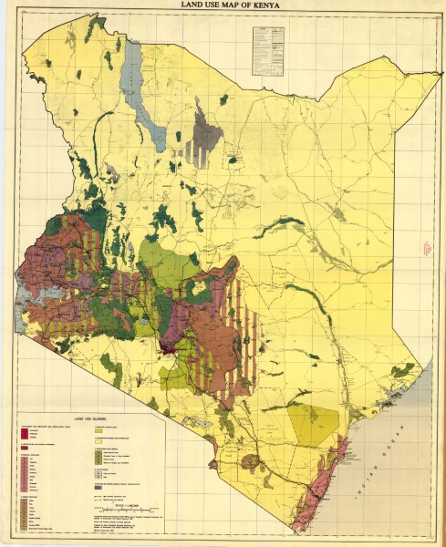
Land Use Map of Kenya 1983
Map shows areas classified by land use type. Types include Settlements and associated non agricultural area, improved and unimproved grazing land, horticultural and market gardening, perennial cropland, arable cropland, woodland and forests water bodies and barren (agriculturally unproductive areas).
Data was compiled from remote sensing data 1972-1980 by Kenya Rangeland Ecological Monitoring Unit, the Ministry of Environment and Natural Resources in 1981.
Simple
- Date (Publication)
- 1983
- Edition
-
1
- Presentation form
- Digital map
- Status
- Completed
- Point of contact
-
Organisation name Individual name Electronic mail address Role Author Kenya Rangeland Ecological Monitoring Unit, Ministry of Environment and Natual Resources
Publisher Ministry of Petroleum and Mining (National Geodata Centre for Kenya)
Custodian Ministry of Petroleum and Mining (National Geodata Centre for Kenya)
Point of contact Owner
- Maintenance and update frequency
- Not planned
- Keywords
-
-
Land Use
-
- Use limitation
-
Internal Only
- Access constraints
- Other restrictions
- Other constraints
-
Internal Only
- Other constraints
- No specifed conditions apply
- Denominator
- 1000000
- Language
- English
- Topic category
-
- Planning cadastre
- Description
-
Kenya
- Supplemental Information
-
{"Translation Needs":"",
"Number of pages (Hardcopy)":"",
"Archive Location (Hardcopy)":"",
"Location in Archive (Hardcopy)":"",
"Risk and Impact":"",
"Vital asset to the organisation?":"",
"Current Asset Volume":"5.73",
"Digitalizing status":"Scanned",
"Scanned Date":"",
"Name of Staff Scanning":"",
"Digital Asset location":" http://gdcs1.gdc.com/SpatialData/Raster/Geological/Land_Use/Land Use Map of Kenya 1983.jpg",
"Retention period":"",
"Shared with":"",
"Comments":""}
- Distribution format
-
Name Version .jpg
- OnLine resource
-
Protocol Linkage Name http://gdcs1.gdc.com/SpatialData/Raster/Geological/Land_Use/Land Use Map of Kenya 1983.jpg Land Use Map of Kenya 1983
- Statement
-
This seems to be the only version of this map produced. It is a stand alone map with no further accompanying information. Scanned copy of published paper map.
Metadata
- File identifier
- f0ad2a34-a546-45f8-bb82-2348aa2b9f04 XML
- Metadata language
- English
- Hierarchy level
- Dataset
- Date stamp
- 2019-10-22
- Metadata standard name
-
National Geodata Centre for Kenya Schema
- Metadata standard version
-
1.0
- Metadata author
-
Organisation name Individual name Electronic mail address Role Ministry of Petroleum and Mining (National Geodata Centre for Kenya)
enquiries
Point of contact
